
Few things in sailing humble you faster than the Adriatic winds. You can be running downwind under blue skies one hour and pinned in a harbor by screaming gusts the next. The Bura alone, a cold katabatic wind that can top 130 km/h, has redirected entire ferry schedules and left inexperienced sailors stranded for days. If you are planning a cruise in the Adriatic, understanding the major adriatic wind patterns is not optional. This guide breaks down every wind that matters, what it does to the sea state, and how to stay ahead of it.
Table of Contents
- Key Adriatic winds every sailor should know
- How Adriatic winds affect sailing and navigation
- Comparing Bura and other northeasterly winds: what sailors must know
- Forecasting Adriatic winds and preparing for sudden changes
- The unpredictable Adriatic: why mastery of local winds is a sailor's edge
- Set sail with confidence using Sailorix's comprehensive resources
- Frequently asked questions
Key Adriatic winds every sailor should know
The Adriatic is a semi-enclosed sea, roughly 800 km long and bordered by mountains on the eastern side. That geography is the engine behind some of the most distinctive adriatic wind patterns anywhere in Europe. The enclosed shape funnels and amplifies winds in ways that open-water sailors find genuinely surprising.
Here are the winds you will encounter most often:
- Bura (Bora): A cold, dry, northeasterly katabatic wind. Cold air masses from the Balkan plateau spill over the Dinaric Alps and accelerate down toward the coast. Bura can exceed 130 km/h, producing short, steep, and dangerous waves that feel nothing like ocean swells. It is most frequent in winter but appears year-round, and it can spin up in under an hour.
- Maestral: A northwesterly thermal breeze that builds in the late morning and peaks in early afternoon during summer. It is predictable, moderate in strength, and consistent in direction. Most experienced Adriatic sailors plan their daily runs around it.
- Siloko (Jugo/Sirocco): A warm, humid southeasterly wind that arrives from North Africa. Unlike the Bura, the Siloko builds gradually and persists. It generates long, rolling swells and reduces visibility through haze and sea spray. Sailors who underestimate it because it feels gentle at first often get caught in deteriorating conditions 12 to 24 hours later.
- Gregal: A cold northeasterly, related to the Bura but steadier and less violent. Expect sustained winds rather than sharp gusts.
- Levanat: A warm easterly wind, generally light to moderate, mostly felt in specific coastal channels.
- Tramuntana: A cold northerly wind, strongest along the Istrian and northern Croatian coast, most common in spring and autumn.
| Wind | Direction | Typical speed | Peak season | Sea state | Sailing impact |
|---|---|---|---|---|---|
| Bura | NE | 50-130+ km/h | Winter (year-round) | Short, steep waves | High risk; shelter often needed |
| Maestral | NW | 15-30 km/h | Summer | Moderate, organized | Ideal for day sailing |
| Siloko | SE | 20-50 km/h | Spring/autumn | Long swells, swell builds | Challenging for novices; risk grows over time |
| Gregal | NE | 25-55 km/h | Winter/spring | Moderate, rough | Demanding but manageable |
| Tramuntana | N | 20-45 km/h | Spring/autumn | Choppy | Moderate difficulty |
| Levanat | E | 10-25 km/h | Variable | Calm to moderate | Generally manageable |
Pro Tip: The Maestral almost always dies by early evening. If you want a calm anchorage approach, plan to arrive after 18:00 when the sea settles. If you are still offshore after the Maestral fades and the Siloko starts filling in from the south, that window closes fast.
How Adriatic winds affect sailing and navigation
Understanding the winds themselves helps, but knowing their real-world sailing effects is critical. Adriatic climate effects on boat handling are specific and often counterintuitive if you have only sailed in the Atlantic or Caribbean.
The Bura is the wind that demands the most respect. Bura creates short, steep waves and sudden gusts that can overpower a rigged sail in seconds. The waves it generates are nothing like oceanic swells. Because the Adriatic is narrow and shallow, Bura waves build quickly without the long fetch of an ocean, resulting in a punishing, close-together chop that is harder to sail through than much larger open-ocean seas.
When Bura strikes, your first job is not to sail through it. Your job is to get into a harbor or bay that offers protection from the northeast. Specifically:
- Identify protected anchorages before departing. Mark at least two fallback harbors on every leg of your Adriatic route. The Bura channels through specific mountain gaps, so bay geometry matters enormously.
- Reef early. Adriatic Bura gusts are not steady increases. They come in pulses. A boat that is properly reefed for 25 knots will survive a 50-knot gust; a boat that is not will not have time to react.
- Monitor barometric pressure continuously. A rapid drop in pressure combined with clearing skies and a sharp drop in temperature is your warning that Bura is loading.
- Avoid night passages during Bura seasons. The wind's gustiness is hard enough to manage in daylight. At night, without visual reference to sea state, the risk multiplies.
The Maestral, by contrast, is the Adriatic's gift to sailors. It builds predictably each summer day as coastal land heats up, creating an onshore pressure gradient. By 11:00 or 12:00, you typically have 12 to 18 knots of clean breeze on a beam reach. The sea state stays organized and the wind direction rarely varies more than 10 to 15 degrees. Many skippers plan their entire summer itinerary around catching the Maestral each day.
"Bura creates short, steep waves and can cause sudden, dangerous gusts, requiring high sailor alertness." That is not hyperbole. Adriatic sailing veterans will tell you that the steepness of Bura waves, not their height, is what catches people off guard.
The Siloko is the slow-building problem. It arrives gently, often feeling pleasant at first, but it is persistent. Long-period swells from the southeast build over 12 to 24 hours, and a boat that left harbor in comfortable conditions can return to a very different sea. The Siloko also pushes sailors into the northwest Adriatic, toward the Italian coast, which can complicate routing if you are not tracking it.
Pro Tip: Watch the horizon to the southeast for a characteristic yellow-gray haze before the Siloko arrives. That haze is Saharan dust and moisture carried north. If you see it building, check your forecast and add a day of buffer to your schedule.
Comparing Bura and other northeasterly winds: what sailors must know
Northeasterly winds share traits but differ critically. Here is how to tell Bura apart from its cousin Gregal and why confusing them creates real risk.
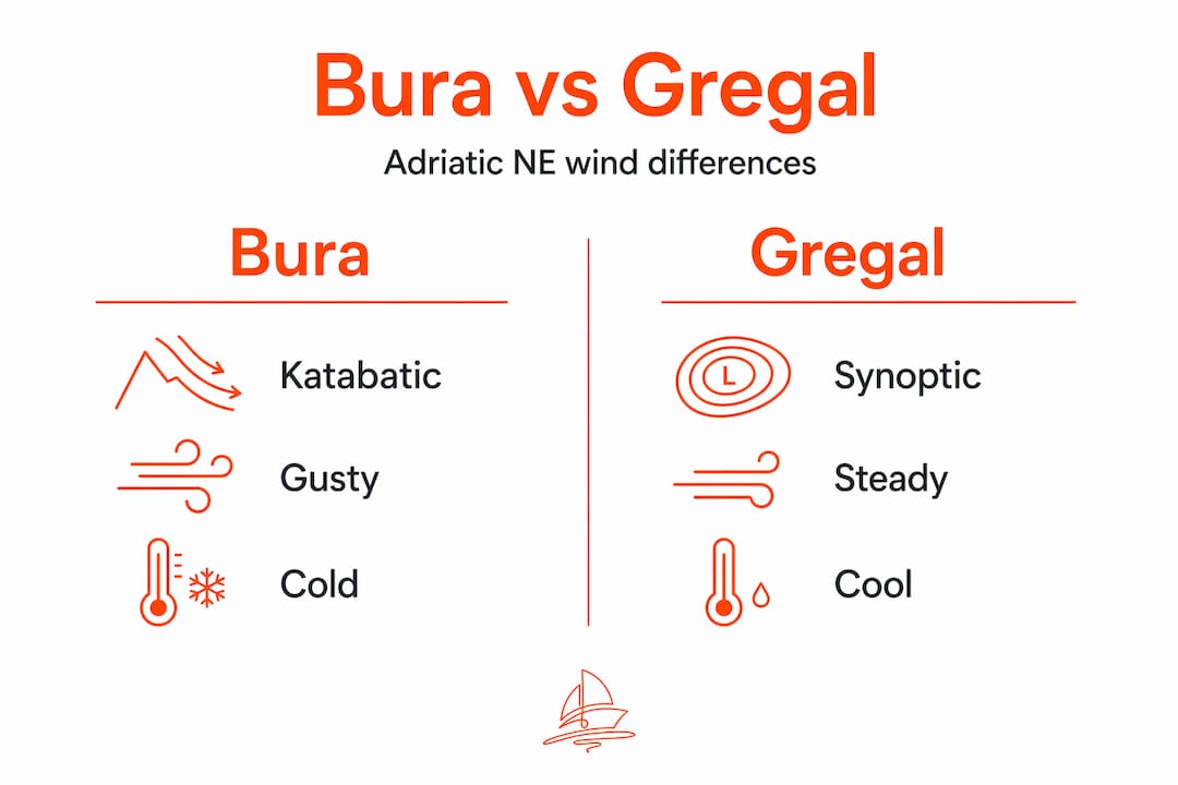
Both Bura and Gregal blow from the northeast. Both occur more often in the cooler months. A sailor who mistakes Gregal for Bura might underestimate conditions; one who mistakes Bura for Gregal might be completely unprepared.
The fundamental difference is mechanical. Bura is katabatic, meaning it is driven by cold, dense air physically falling down from the mountains above the Dalmatian coast. That descent creates explosive acceleration. Gregal is steadier and less violent than Bura, without extreme gusts, though it can still produce rough conditions. Gregal is driven by synoptic pressure systems rather than mountain topography, so its behavior is more consistent and predictable.
How to distinguish them in practice:
- Onset speed: Bura can go from flat calm to 60 knots in 30 minutes. Gregal builds over hours.
- Gust-to-lull ratio: Bura's gusts can be double the lull speed. Gregal stays within a narrower range, rarely more than 30 to 40 percent above the mean.
- Visual onset: Bura is often preceded by a band of cloud clearing and a sudden temperature drop. Gregal typically arrives under gray overcast skies without a dramatic visual shift.
- Geographic focus: Bura is strongest in specific mountain gap zones: the Velebit channel, Šibenik gap, and Split area. Gregal is more spread across the central and southern Adriatic.
- Duration: Bura can last hours or several days in distinct episodes. Gregal tends to persist more uniformly until the pressure system moves on.
| Feature | Bura | Gregal |
|---|---|---|
| Origin mechanism | Katabatic (mountain descent) | Synoptic pressure gradient |
| Peak gust variability | Extreme (2x lull or more) | Moderate (1.3-1.4x lull) |
| Onset | Sudden, 30-60 minutes | Gradual, 6+ hours |
| Strongest zones | Northern/central Dalmatian coast | Central/southern Adriatic |
| Season | Winter primary, year-round | Winter/spring |
| Sailor risk level | Very high | Moderate |
Underestimating the difference has consequences. Sailors who have sailed through Gregal before and survived fine sometimes apply the same tolerance to Bura conditions, with very different outcomes.
Forecasting Adriatic winds and preparing for sudden changes
Knowing the winds' nature is vital, but anticipation and preparation keep you safe when they turn fierce. Forecasting the adriatic winds is a mix of reading numerical models, watching physical indicators, and adjusting for local geography.
Bura can arrive suddenly with little warning, blowing in gusts rather than steadily, lasting from a few hours to several days. That means no forecast is a guarantee. But there are reliable physical precursors if you know what to look for.
Steps to prepare your vessel before forecasted strong wind:
- Check the Adriatic wind forecast on Windy.app at least 48 and 24 hours before any planned passage.
- Look for wind speed, gust differential, and direction consistency across multiple model runs. If models disagree, treat the strongest scenario as your planning baseline.
- Secure all loose gear on deck: fenders, lines, anything not attached. Bura gusts show no mercy for unlashed equipment.
- Check rigging tension and inspect shackles. Bura's repetitive gusting load fatigues connections faster than a steady wind at the same average speed.
- Identify and chart your harbor alternatives along the planned route, specifically bays that protect from the northeast.
- Brief your crew on the plan, the fallback options, and what role each person plays if conditions deteriorate quickly.
Pro Tip: Rapid barometric pressure changes, dropping more than 3 hPa in three hours, are a classic Bura signal. Combine that with clearing skies and cooling air and you have a strong case for delaying your departure by at least a day.
Local DHMZ (Croatian Meteorological and Hydrological Service) forecasts are specific to the Adriatic and worth cross-referencing against global models. Croatian mariners have monitored these patterns for centuries, and the regional forecasts reflect knowledge that generic global models sometimes miss.
The unpredictable Adriatic: why mastery of local winds is a sailor's edge
Here is a perspective most sailing blogs will not offer: the gap between a skilled Adriatic sailor and an inexperienced one is not equipment or boat quality. It is wind literacy.
Modern apps have made passage planning more accessible. But no app captures the specific way a Bura funnels through the Velebit channel at three in the morning, or why a bay that shows as sheltered on the chart still gets hammered when the wind shifts five degrees north of northeast. That knowledge lives in the people who sail these waters every season, and in the sailors who pay close enough attention to build their own models of how local geography shapes the winds of the Adriatic.
There is a contrarian argument worth making: over-reliance on digital forecasts can actually make sailors more vulnerable, not less. When every wind decision runs through an app, sailors stop reading the physical environment. They stop noticing the temperature drop on their skin, the change in the sea's surface texture, the particular smell of a cold air mass descending. These signals routinely precede Bura by 20 to 30 minutes, which is often enough time to get sail down and reach shelter. Apps update every few hours. The sea moves faster than that.
The atmosphere after a Bura is exceptionally clear, with outstanding visibility and a deep, sharp blue sky. Experienced Adriatic sailors will tell you that post-Bura clarity is the visual metaphor for what the wind teaches you about the sea if you are willing to stay observant. The best sailors in this region are not the ones with the most technology. They are the ones who have learned to read what the Adriatic shows them before it becomes a crisis.
Seasonal winds in the Adriatic also change character as you move south. Winds that feel moderate near Zadar can be considerably stronger near Split, and the Pelješac channel creates its own accelerated corridor that surprises sailors who do not know it. Local knowledge, gained either firsthand or from sailors who know these waters well, is irreplaceable.
Set sail with confidence using Sailorix's comprehensive resources
With knowledge and preparation in hand, Sailorix can empower your next Adriatic voyage with practical guidance and community support. Understanding adriatic wind patterns is one thing. Booking a boat that matches your experience level and the season's conditions is where planning becomes real.

At Sailorix, you get access to tailored sailing guides, safety checklists, and a community of sailors who know these waters. The membership model keeps costs low, so your €100 annual fee goes toward actual sailing instead of platform fees. Whether you are timing your trip around the summer Maestral or need a vessel rated for Bura-season passages, the platform gives you the tools to make those decisions confidently. Stop letting booking fees eat your sailing budget and start spending it where it matters.
Sailorix features that directly support Adriatic sailing:
- Real-time boat availability across Croatian marinas
- Sailing guides specific to Adriatic conditions and seasonal winds
- Safety checklists covering wind, weather, and boat preparation
- Community forums with experienced Adriatic sailors
- Only ~1% service fee vs. the 10-20% charged elsewhere
Frequently asked questions
What is the strongest wind in the Adriatic Sea?
The Bura is the strongest wind in the Adriatic. It is a cold, dry, katabatic northeasterly that can produce hurricane-force gusts over 130 km/h, particularly in the northern Adriatic near the Dalmatian coast.
How does the Bura wind affect sailing conditions?
Bura produces short, steep waves and explosive gusts that demand immediate sail adjustments and often force sailors to seek shelter. Short, steep waves combined with sudden gusts make it one of the most dangerous sailing conditions in the Mediterranean.
When is the Bura wind most common?
Bura is most frequent during winter but can occur in any season. It tends to arrive suddenly, with little warning, and can persist anywhere from a few hours to several days.
What wind is best for leisurely sailing in the Adriatic?
The Maestral is widely considered the best wind for relaxed day sailing. It is a predictable, constant northwesterly that builds reliably each summer afternoon, offering moderate, consistent conditions ideal for both beginners and experienced cruisers.